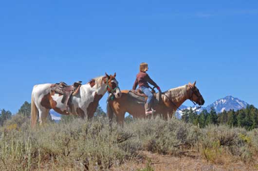
Horseback Riding around Donner Summit
Horseback Riding around Donner Summit is a popular activity for riders who enjoy exploring new trails. Camps designated for equestrians are found scattered around the Tahoe National Forest along the Donner Summit corridor. Some camps are specifically for campers with horses, others allow both regular camping and horse camping.
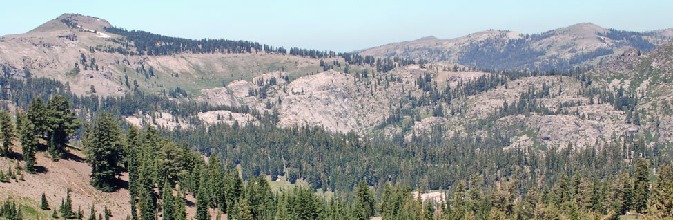
Miles of riding trails wind through the Sierra on both sides of Donner Summit. Horses are allowed virtually anywhere hikers can go. The Pacific Crest Trail leading north and south from the summit offers many miles of riding on a well-maintained route. Paralleling Highway 20, the 25-mile-long Pioneer Trail can be accessed from many places along its course. We highlight many of the best riding areas here and include maps of many trails.
Equestrian Camps
Robinson Flat Campground
Located 27 miles northeast of Foresthill at 6,800 feet. The approach road is narrow and winding, making it unadvisable for large trailers. The campground is located on the Western States Trail. This remote site has no trash removal.
Campground Amenities
- 7 family campsites and 7 equestrian campsites, vault toilets
- Water is hand-pumped from a well
- Picnic tables, fire rings, grills
- Motorcycle OHV nearby
Reservations: None
Fees: None
Shop Amazon: Camping Essentials
Aspen Group Campground
Located north of Truckee on the north shore of Jackson Meadows Reservoir. From Truckee drive 17 miles north on Highway 89 to Little Truckee Summit, then travel left on Forest Road 7 sixteen miles, The campground is at an elevation of 6,100 feet, with views of the Sierra Crest and English Mountain. The campground is usually open from mid-June through mid-October.
Campground Amenities
- 3 group sites (2 sites for up to 25 people, 1 site for up to 50 people)
- Piped water, vault toilets, picnic tables, grills, fire rings
- Nearby dump station, swimming beach
- Boating, water skiing, swimming fishing
Reservations: contact the Nevada Irrigation District at 530-265-5302.
Fees: $126 or $252 per site
Little Lasier Meadow Horse Camp
Located north of Truckee in a meadow near about 2 miles from Jackson Meadows Reservoir. From Truckee drive 17 miles north on Highway 89 to Little Truckee Summit, then travel left on Forest Road 7 sixteen miles. At East Meadow Campground turn left down Forest Road 80 for 1.3 miles. The campground is usually fully open from mid-June through October. Later in the season services may be limited. The campground is at 6,500 feet.
Campground Amenities
- 11 campsites, vault toilets, piped water
- Picnic tables, fire rings, grills
- 4 corrals, hitching posts
- Riding trails, access to Pacific Crest Trail, nearby lake for swimming, fishing, boating
- Nearby boat launch ramp and dump station
Reservations: (877) 444-6777 or
Recreation.gov - Little Lasier Meadow Horse Camp
Fees: $24 per site, $5 for extra vehicle
Boca Spring Campground
Located one mile east of Boca Reservoir at 5,700 feet amid a heavy forest of Jeffrey pines and firs. Horses are allowed at the campground. One group site at the campground can accommodate from 25 people. The campground is at 5,900 feet and is usually open from mid-May to mid-October.
Campground Amenities
- 14 campsites 13 for tents and RVs up to 20', 1 group site for up to 25 people and 8 vehicles
- Vault toilets, piped water, corral
- Grills, fire rings
- Hiking, horseback riding, OHV nearby
Reservations: (877) 444-6777 or Recreation.gov - Boca Spring Campground
Fees: $20 per night, $5 for extra vehicle; $66 for the group site
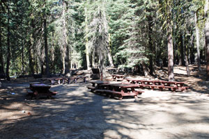
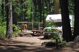
Skillman Horse Campground
Located at 4,600 feet, 14 miles east of Nevada City off Highway 20. The campground is designated for campers with horses. Each site can accommodate up to 6 people, 4 horses, and 2 vehicles. A group area is made up from 5 smaller sites and can accommodate up to 36 people, 24 horses, and 12 vehicles. Large trucks and trailers will require the space of multiple vehicles. The campground is usually open from the end of May through the end of September.
Campground Amenities
- 12 campsites, vault toilets, piped water
- Picnic tables, fire rings, grills
- Corrals: Site 4 has 2 corrals, sites 7,9,13, and 15 each have one corral
- Hitching posts and horse troughs
- Pioneer Trail nearby for hiking, equestrian, and mountain biking
Reservations: (877) 444-6777 or Recreation.gov - Skillman Horse Campground
Fees: $18 for single unit, $36 for double site
Popular Equestrian Trails
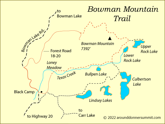
Bowman Mountain Loop
Trailhead: Forest Road 18-20 or Loney Meadow Trailhead on Bowman Lake Road
Distance: 8.5 mile loop
The Bowman Mountain loop trail begins at the junction of Bowman Lake Road and Forest Road 18-20. Ride up a dirt road around the northwest shoulder of Bowman Mountain. At mile 2.5 switch onto the trail which continues to circumnavigate the mountain. The route climbs a little over a thousand feet in three miles and then descends to join the Lindsey Lake trail near Upper Rock Lake (mile 4.25).
Turn right onto the Lindsey Lake trail, following it southwest until you reach a trail junction at about mile 5.0. Turn right, heading west away from Culbertson Lake, passing Bullpen Lake and Loney Meadow. At mile 7.0 turn right again to Black Camp on Bowman Lake Road. Follow the road north 1.5 miles to your starting place.
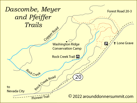
Dascombe, Meyer and Pfeiffer Trails
Trailhead: Lone Grave on Highway 20
Distance: 4.2 miles
The 1.4-mile Dascombe Trail, the 2.1-mile Meyer Trail, and the 1.7-mile Pfeiffer Trail are a network of interconnecting trails and dirt roads off Highway 20 across from Lone Grave and around the Conservation Camp. The trails also connect with the 25-mile-long Pioneer Trail that parallels Highway 20.
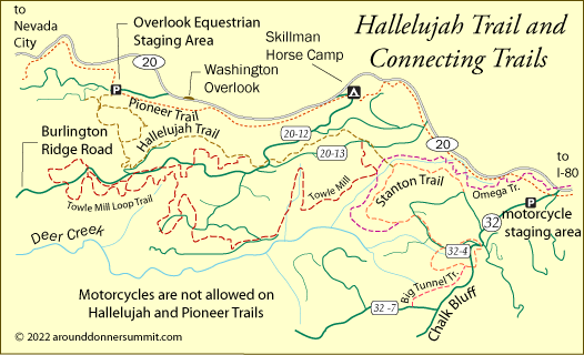
Hallelujah Trail
Trailhead: Hallelujah Trailhead on Forest Road 20-9 across from Washington Overlook on Highway 20
Distance: More than 10 miles of trail
The Hallelujah Trail is part of a network of multi-use trails that spreads south of Highway 20 near the Washington Overlook and Skillman Horse Camp. Among the connected trails are the Stanton Trail, Towle Mill Trail, and Big Tunnel Trail. The Pioneer Trail passes through the area, paralleling Highway 20. Motorcycles are not permitted on the Hallelujah and Pioneer trails.
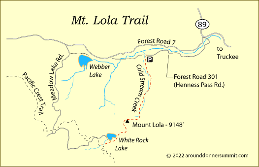
Mount Lola Trail
Trailhead: Henness Pass Road at Perazzo Meadows on the Little Truckee River
Distance: 8 miles one-way
The Mt. Lola Trail begins at a trailhead on the Henness Pass Road (Forest Road 301), 5 miles east of Highway 89. The trail leads south up Cold Stream Canyon (not to be confused with the Coldstream Canyon near Donner Lake). The route climbs steadily toward the summit of Mt. Lola, rising from 6,500' at the trailhead to 9,148' on the summit in 5 miles. Continuing on the trail, you descend to the southwest, passing White Rock Lake shortly before meeting the Pacific Crest Trail, 9 miles north of Donner Summit.
Painted Rock Trail
Trailhead: Soda Springs, 11 miles south of the town of Soda Springs
Distance: 3.7 miles one-way
Find the trailhead for the Painted Rock Trail by driving south out of Soda Springs on Soda Springs Road. After 9.5 miles turn left on a dirt road leading out to the trailhead at the actual Soda Springs. Painted Rock Trail passes over the shoulder of Painted Rock Peak and then dips to follow the upper section of the American River. At mile 3 it leaves the river and climbs to intersect the Pacific Crest Trail.
One interesting, but challenging, addition to the ride is to continue south on the PCT 1 mile and then turn left (east) onto Granite Chief Trail, descending to Squaw Valley (another 3 miles and a 2000-foot drop). Another option is to stay on the PCT for another 1.5 miles to the shoulder of Granite Chief Peak and enjoy the great views down into Palisades Tahoe (formerly Squaw Valley).

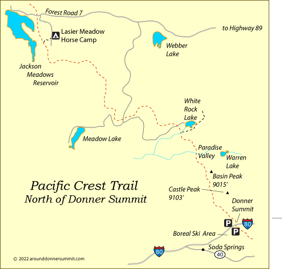
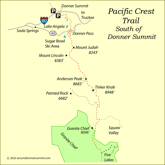
Pacific Crest Trail
Trailhead: Donner Summit (I-80) or Donner Pass (Highway 40)
Northbound (see Southbound below)
Popular Northbound Destinations: White Rock Lake (10 miles), Jackson Meadows Reservoir (24 miles)
From Donner Summit, the PCT climbs over Castle Pass with Castle Peak rising to the east. After dipping into Round Valley, the trail ascends to its highest point, 8,400 feet, and then drops into Paradise Valley, a nice stopping place (mile 7.5). Near mile 10 the PCT intersects the Mt. Lola Trail. White Rock Lake is just half a mile up the Lola trail. At mile 18 begins a long descent to Jackson Meadows Reservoir (6,000'). Lasier Meadow Horse Camp is only a mile east of the lake.
Southbound on the PCT
Popular Southbound Destinations: Anderson Peak (9 miles), Five Lakes (19 miles)
Heading south from Donner Summit the PCT crosses 3 miles of easy terrain to Donner Pass (Highway 40). There the trail begins steep switchbacks up to a ridge by Mount Judah. Sugar Bowl Ski Area is off to the west. Once above the switchbacks, the trail is much easier, climbing gradually up past Mount Lincoln and along the ridge to Anderson Peak (mile 9). The trail follows the
ridge to distinctive Tinkers Knob and then makes a 1,200-foot descent to the American River. Then the PCT climbs to Granite Chief, enters the Granite Chief Wilderness, and drops down to Five Lakes (mile 19).
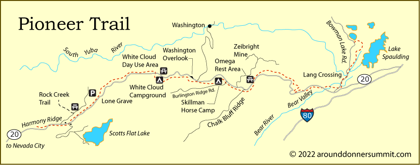
Pioneer Trail
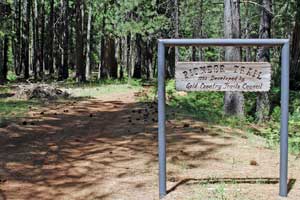
Distance: 25 miles one way
Starting Points: Along Highway 20 east of Nevada City: Harmony Ridge Market, Lone Grave, White Cloud Picnic Area, Washington Overlook trailhead, Skillman Horsecamp (shown below), Upper Burlington Trailhead, Chalk Bluff trailhead, Omega Rest Stop, Ziebright Mine, and on Bowman Lake Road access at Lang crossing. (see map below)
The Pioneer Trail parallels Highway 20, climbing and descending. In many places the trail passes through open forest, while at times (such as near Skillman Horsecamp) the trail is narrow and densely forested.
At Bowman Lake Road the trail follows the road to the South Yuba River at Lang Crossing. From there it climbs nearly solid rock, then moves into oak woodlands before entering mixed conifers and joining the Spaulding Lake trail at a penstock (pipe). There the bike route turns left and travels a quarter mile back to Bowman Lake Road.